1. Rapid Response: Drones can quickly reach emergency sites, providing real-time information to first responders and helping them make informed decisions. This includes:
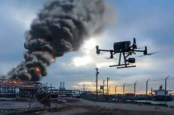
– Fire departments using drones to quickly assess fire scenes, providing information on the fire’s spread, potential hazards, and optimal entry points;
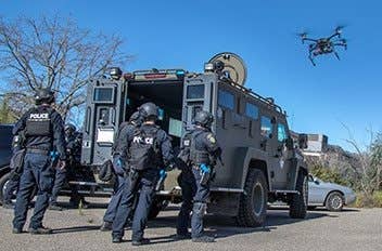
– Law enforcement agencies deploy drones to rapidly assess active shooter or hostage situations, improving response times and tactical planning.
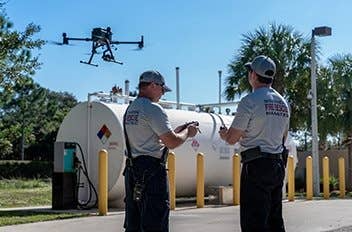
2. Improved Safety: Drones can be used in dangerous situations, such as fires or hazardous materials incidents including chemical spills and radiation leaks without exposing themselves to unnecessary risks.
– Search and rescue teams use drones to scout dangerous or inaccessible areas, reducing the risk to rescue personnel.
3. Enhanced Situational Awareness: Emergency medical services use drones to evaluate accident scenes, allowing them to better triage patients and allocate resources. Law enforcement agencies employ drones for aerial surveillance during large public gatherings, helping monitor crowd movement and detect potential threats.
4. Cost-Effective: Drones are often less expensive than manned aircraft, providing a cost-effective way for agencies to gather information and respond to emergencies. This also comes in handy for:
– Rural Fire Departments: Rural fire departments with limited resources use drones for aerial support during wildfires, quickly assessing fire spread and planning safe firefighting strategies without the expense of manned aircraft.
– Small Police Departments: Drones provide a budget-friendly solution for small police departments, offering aerial surveillance during investigations, search operations, or public events without the high costs associated with police helicopters.
– Emergency Management in Remote Areas: In remote regions, emergency management agencies deploy cost-effective drones for post-disaster assessments, victim location, and aid delivery, eliminating the need for expensive manned aircraft or extensive ground teams.
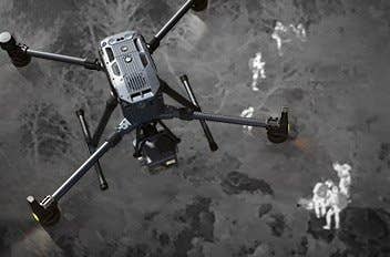
5. Increased Accessibility: Drones can easily access remote or hard-to-reach areas, making them invaluable in SAR missions – like Coast Guard and maritime rescue agencies using drones to access and survey rocky coastlines or remote islands in search and rescue operations.
6. Extended Operational Hours: Drones equipped with thermal imaging cameras can operate in low-light conditions or at night, extending the operational hours of public safety agencies.
– Border patrol agencies monitoring borders to detect illegal activities;
– Wildlife agencies monitoring nocturnal animals to track and protect endangered species;
– SAR operations to locate missing individuals;
– Law enforcement agencies deploying drones to detect illegal drug cultivation or smuggling activities that are prevalent at night.
7. High-Quality Data Collection: Drones can capture high-resolution images and videos, as well as other data, providing valuable insights for situations like:
– Accident Scene Reconstruction: Law enforcement agencies use drones to capture detailed aerial images of accident scenes, creating accurate 3D models for analysis. The data aids in determining the cause, assess liability, and improve traffic safety measures.
– Wildfire Damage Assessment: Fire departments and emergency management agencies deploy drones to capture high-resolution images of areas affected by wildfires. That way they can assess the extent of the damage, identify potential hazards, and plan for post-fire recovery and reforestation efforts.
– Forensic Investigations: Forensic teams use drones to capture detailed aerial imagery of crime scenes, creating comprehensive 3D reconstructions for analysis. This helps investigators piece together the sequence of events, identify potential evidence, and assist in solving crimes.
8. Flexible Deployment: Drones can be quickly deployed and repositioned as needed, providing flexibility in responding to dynamic situations. For instance:
– Flood Response: In the aftermath of floods, drones can be quickly deployed to assess damage, locate stranded individuals, and help plan rescue efforts. Pilots can swiftly adapt to the changing situation and adjust their flight paths as needed to cover affected areas and respond to emerging needs.
– Protest Monitoring: During large protests or demonstrations, law enforcement agencies can deploy drones to monitor crowd movements and identify potential flashpoints. Drones can be rapidly repositioned to focus on specific areas or follow the crowd, enabling a flexible and real-time response to any emerging security concerns.
– Earthquake Recovery: Following an earthquake, drones can be deployed to assess structural damage, identify unsafe buildings, and help coordinate recovery efforts. As the situation evolves and new areas of concern are identified, drones can be easily redirected to survey new locations and provide updated information to emergency responders.
9. Improved Communication: Drones can serve as temporary communication relays, enhancing communication between first responders and command centers during large-scale emergencies. This includes:
– Wildfire Response: During wildfires, drones equipped with communication devices can extend the range of radio signals, allowing firefighters and incident commanders to stay connected even in remote areas.
– Urban Search and Rescue: In the aftermath of earthquakes or building collapses, drones can provide temporary communication relays, helping search and rescue teams communicate with each other in areas with damaged cell towers or communication infrastructure.
– Mass Casualty Incidents: In mass casualty situations, drones can help establish a temporary communication network, enabling emergency medical responders to coordinate triage and patient transport more effectively.
10. Public Engagement: Drones can provide live video feeds during public events or emergencies for:
– Community Outreach: Law enforcement agencies use drone footage to showcase their efforts in combating crime and serving the community, enhancing public trust and engagement.
– Environmental Conservation: Capturing footage of protected areas, enabling the agencies to showcase their conservation efforts and raise public awareness about the importance of preserving natural habitats.
– Disaster Preparedness: Emergency management agencies use drones to document their disaster response training and exercises, sharing the footage with the public to raise awareness about the importance of disaster preparedness and community resilience.